

Wainui Reserve is a Waikato District Council owned 140 hectare farm park giving access to Ngarunui Beach. Vehicle entry to the reserve and through it to the beach carpark is from Wainui Road.
You can also enter the Wainui Reserve at the north eastern end from Riria Kereopa Memorial Drive (formerly Ocean Beach Road), at the end of which the reserve begins. If you are walking from Raglan this is the best way to come. Except at spring high tides you can walk about 6km along the beach to the far south western end of Ngarunui Beach.
The picnic area road access and car park is locked from dusk to dawn to stop overnight camping.
Things to do at Wainui Reserve
Walking
In addition to simply walking along the beach getting sand between your toes, there are a number of bush and farm tracks in the Wainui Reserve. (Notes supplied by John Lawson)
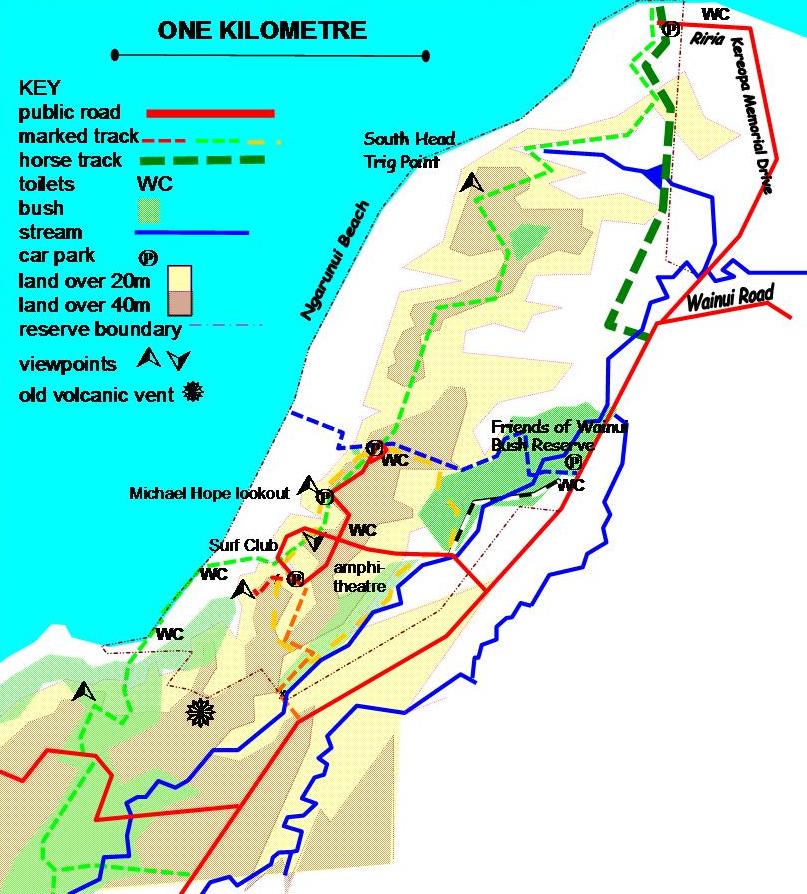
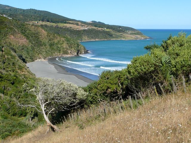
Cliff top to beach – shown as a dashed green line on the map below.
At the end of Riria Kereopa Memorial Drive, leave the beach at the car park and climb up the grassy track to a gate, then turn right and follow the green arrows. Most of the track to the Trig Point is through pine forest, but there are some good views up the coast. On a clear day the Waitakere ranges west of Auckland can be seen.
The Trig Point is only 81 metres above sea level, but gives good views of the coast, harbour, Raglan and Karioi. The reserve was originally set aside by the government as the Pilot Reserve to provide a lookout for ships and a lighthouse. The lighthouse was never built and the reserve transferred to the council. Council planned to sell most of the reserve, but local protest, supported by Cr Michael Hope, saved most of it.
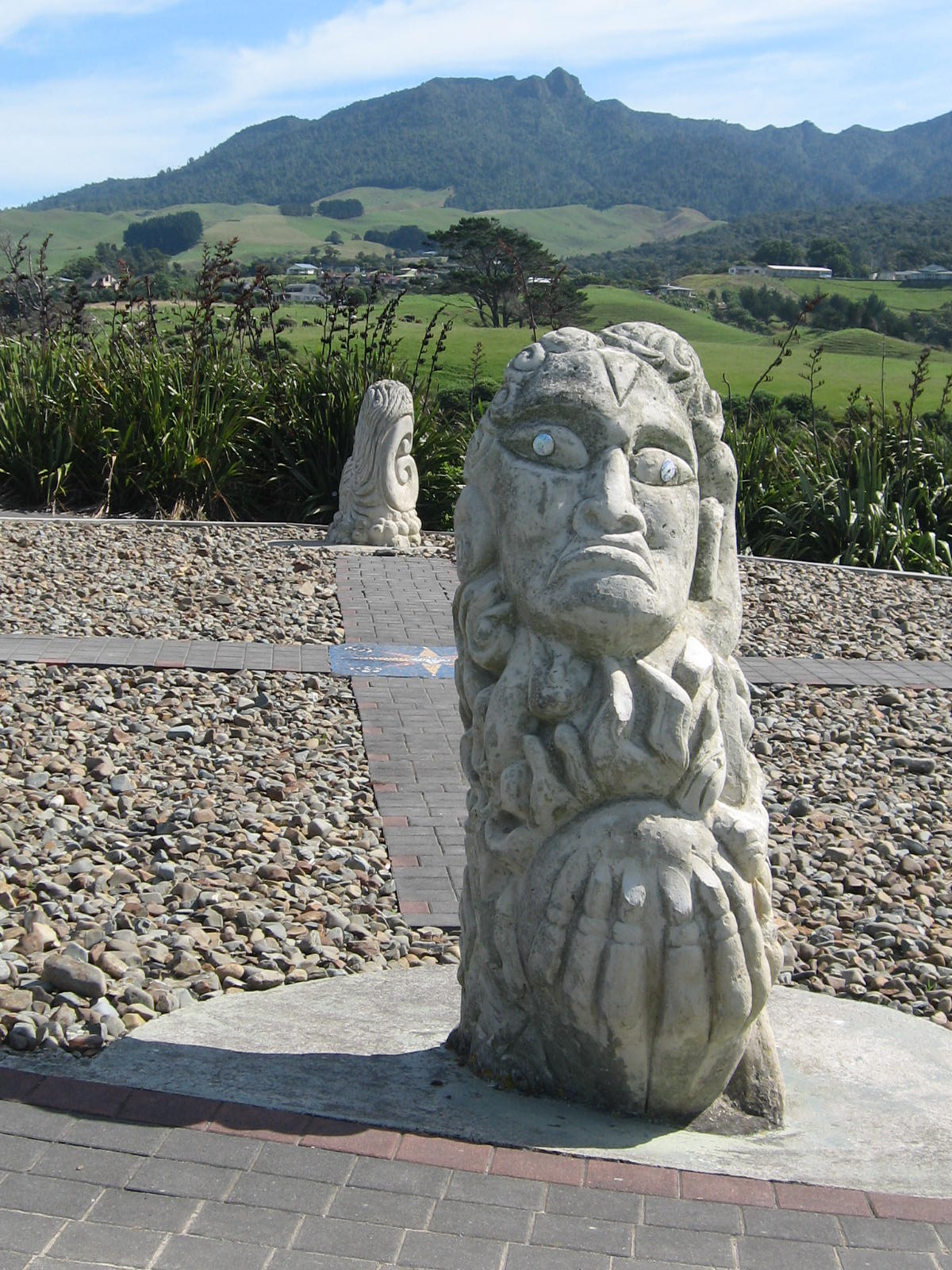
From the Trig Point the track keeps on the ridge as it drops to the car parks. To the left Pirongia is on the skyline, another former volcano, like Karioi. Keep along the cliff top passing the 2002 sculptures representing north south east and west, then drop down past the Surf Lifesaving Club to the beach. Turn left opposite the lifeguard lookout station until reaching the green finger post sign above the beach. The track climbs up through bush from the toilet about 200 metres south of the lifeguard lookout.
A good view of the beach is from the lookout in the Bryant Reserve. Look too here at the wind sculpted akeake and tea trees with pohutukawa standing a bit higher. The track continues up to Wainui Rd (there are also steps to the right up to Earles Pl). Cross Wainui Rd, turn left and just on the corner a clearly defined track left through the bush is signposted. In the 1920s a power house was built to generate electricity for the Bryant camp and the channel alongside this track fed water from the Wainui Stream to a water turbine above the beach. An iron pipe took the water across the valley and remnants of it can still be seen. Cross the valley up to a 4 way junction of paths. Straight ahead gives a pleasant detour to Wainui Stream. Otherwise turn left, then right downhill to cross Wainui Stream on a sturdy DOC bridge and up to Upper Wainui Rd. The choice here is to return the way you’ve come, or take care walking along the road to reach the ridge and stream.
Ridge and Stream Track – shown as a dashed orange line on the map
A useful link from Wainui Road to the centre of the reserve with widespread planting by Whaingaroa Harbourcare. The entrance is between 470 and 472 Wainui Rd.
Bush to Beach – shown as a dashed blue line on the map
A lot of planting has also been done by the Friends of Wainui who have transformed part of the Wainui valley from farm to bush reserve. From their car park this track crosses the stream, climbs through the bush reserve, crosses the ridge, then descends to a walkway over the dunes to the beach.
Wainui Valley – shown as a dashed green line on the map
The other marked track from the Friends car park follows the valley, passing water features created by the Friends, to reach Ngarunui Beach Rd a the yellow circuit.
Yellow Circuit – shown as a dashed yellow line on the map
This track links the main parking areas with the Wainui valley and passes through several areas planted over recent years.
Lookout Track – shown as a dashed red line on the map
This short track goes uphill from the main car park to one of the lookout points.
The amphitheatre is used as an occasional venue for concerts, weddings, etc. The acoustics, grass terraced seating and views of Karioi make it a unique venue. Bookings can be made through the Waikato District Council’s Raglan office – 07 825 8129.
Geology Like most of the Raglan area the reserve is made of 2 to 3 million years old Okete volcanics; lavas, tuffs and scoria. The dunes are recent and constantly eroding and building, often changing several metres in a year, both vertically and horizontally.
Plants Many trees in the Friends of Wainui Bush Reserve are labelled. The main dune grasses are marram and the natives, spinifex (the yellow spiky seed heads are often seen blowing along the beach) and pingao (a darker green).
Birds The ones most commonly seen on the reserve are sparrows, yellowhammers, magpies and skylarks. There are also some piwakawaka (fantails), and kereru (pigeon) and the tui’s belllike song can often be heard in the Bryant Reserve.
[ad name=”Google Adsense”]
Mountain Biking and Cycling
Cycling is permitted throughout the reserve, though there are no specific facilities. Care should be taken on the roads and on tracks when pedestrians are present.
Horse Riding
Horses are welcome to use the marked track from Wainui Rd through the pine plantation to the beach. Please leave gates as you find them. Horses are not allowed on the emergency access road between Surf Club and beach.
Kite Boarding and Parasailing
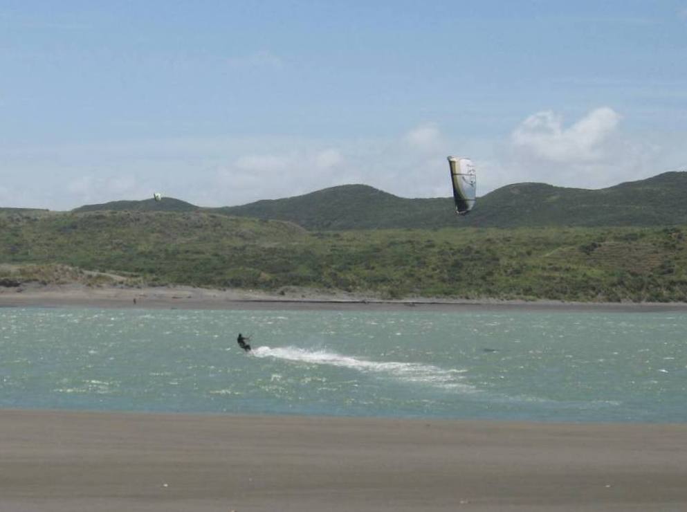

The area at the north-eastern beach at the harbour mouth has strong consistent winds that attract kite boarders, while the clifftop edge provides a good zone for parasailing.
Fishing
Rangipu at the north-eastern beach just along from the harbour mouth is a popular spot for shore fishers. Access is by walking along the beach from the car park at the end of Riria Kereopa Drive.
Getting to Wainui Reserve
From Raglan drive down Wainui Road, keep going across the one way bridge, continue on Wainui Road passing Poihakena Marae on the right, Kereopa Drive on the right, and turn right into the Wainui Reserve access road. Follow the road until you come to a traffic island. Go straight ahead for the surf beach access and car parks. During the peak summer period the car parks fill up quickly and overflow carparks are opened on the adjacent farm areas. Turn right for lookouts and picnic areas and other parking areas.
There are a number of public toilets and changing rooms in the reserve.
Public Bus Service to Wainui Reserve
A limited Manu Bay bus service that also stops at Wainui Reserve above Ngarunui Beach, runs twice a day on Saturday is provided from Hamilton Terminal and Raglan by the Route 23 bus from November to April.
To download the Hamilton to Manu Bay, Raglan bus timetable click here, click here or to view it as a web page click here
There is no public bus service to Wainui Reserve and Ngarunui Beach during the winter months. Hitchhiking is a popular way of getting from Raglan to Ngarunui Beach. Head out from Raglan and start thumbing a ride when you are past the Union Church on the corner of Stewart Street and Wainui Road.
Wainui Reserve Bay Satellite View
[SGM lat=”-37.81800″ lng=”174.83250000″ zoom=”16″ type=”SATELLITE”]
View Larger Map
…
Accommodation
Awesome Views Manu Bay Holiday Accommodation

Set in native bush this timberline apartment has private entrance, shower, kitchen etc. The lounge and 2 private bedrooms open to a deck overlooking one of the premier surf breaks on the planet, Manu Bay.
 The accommodation is downstairs separated from the main house. Four kilometres from Raglan township on Manu Bay road. It is a five minute walk to the beach via a well maintained track at the back of the house.
Book Awesome Views Manu Bay now by clicking the Bookit Button:
![]()
Cbarn Coastal Accommodation
Just a few minutes walk from Ngarunui Beach, C’Barn allows you to check out the famous Raglan surf from bed. The hilltop barn offers contemporary holiday accommodation, purpose built for the views and sun. Enjoy the unique sense of space created by fibre artist, Jean Carbon, which has been described by one American traveller as “the best accommodation” he’d experienced in New Zealand during his four months of travel here.
For enquiries and bookings please contact Jean. Phone +64 7 825 8877
Hi how do i book im getting married and am looking for a location for the ceremony can i do it at the wainui reserve?
I suggest you contact the Raglan office of the Waikato District Council on 07 825 8129.
They will be able to handle your booking request.
Cheers,
Rodger