Raglan 23

≡ Menu
  • Home
  • What’s On
    • Events this month
    • Movies in Raglan
  • Directory
    • The Raglan Directory Info
    • Eat/ Drink
    • Health/ Wellness
    • Accommodation
    • Our Community
      • Community Organisations
    • Prof/Trade/Serv
    • Retail
    • Activities/ Venues
    • : Bow St/Bus Areas
    • – Our Members
  • Visitor Info
    • Cafes
    • Pipiwharauroa Walk/ Bike Trail
    • Bridal Veil/ Waireinga Falls
    • Wharf
    • Free or cheap visitor activities
      • Heritage Walks
      • Arts in Raglan
      • The Road to Raglan
    • Getting to Raglan
      • Getting away from Raglan
      • Driving & Flying
      • Maps
    • Fishing
      • Launching ramps
      • Manu Bay Fishing
      • Wharf Fishing
    • Ask a question/ FAQ
      • Dogs in Raglan
      • Getting around
    • Photos
      • Raglan Ramblers photos by John Lawson
      • Richard Gallagher’s Raglan photos
      • Rodger’s Raglan photos
      • NZSURFPIX Raglan photos
      • Te Uku Wind Farm photos
      • Art To Wear
      • Videos
    • Self Catering
  • Beaches, Surf
    • Raglan Surf
    • Bush Park Wainui
    • Raglan Domain Papahua/ Te Kopua
      • Papahua Pump Track
      • Te Kopua Fitness Trail
    • Manu Bay
    • Ngarunui Beach
    • Walking Ngarunui
    • Wainui Reserve
    • Whale Bay
  • Weather
  • Holiday Accommodation
    • Backpackers
    • Holiday & Caravan Parks + Camping
    • Hotels & Motels

Bridal Veil/ Waireinga Falls near Raglan

by Rodger
Visitor studies the cascading flow of the Bridal Veil/ Waireinga Falls

Visitor studies the cascading flow of the Bridal Veil/ Waireinga Falls

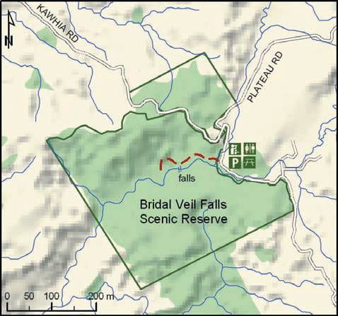
The Bridal Veil/ Waireinga Falls are located 5km East of Te Mata.  Coming from Raglan on SH 23 turn right into the Te Mata Road.  (Coming from Hamilton or Whatawhata turn left off SH 23 a few minutes past Te Uku.)  Continue through the Te Mata village and follow the signs to the car park outside the entrance to the reserve.  Waireinga means leaping waters, referring to wairua (spirits) leaping the great height of this waterfall. Waireinga is also spiritually known by tangata whenua (people of the land) to be occupied by Patupaiarehe (Maori fairies) who are kaitiaki (guardians) of the area.

Track to top of Bridal Veil/ Waireinga Falls following the Pakoka River

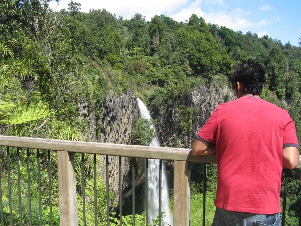
The reserve is maintained by the Department of Conservation who completed a major upgrade of tracks and steps in 2011.   There are public toilets just inside the entrance to the reserve.   A little further on there is a picnic table.   It is an easy walk to the top of the Bridal Veil/Waireinga Falls following the Pakoka River for most of the way. The track is through a native forest canopy and is suitable for pushchairs and wheelchairs to the two viewing platforms at the top.  The walk from the carpark to the top of the falls takes about 10 minutes each way.  The water flowing in the Patoka River has journeyed a long way from its headwaters in the forests on Pirongia.  It is the home to eels (tuna), freshwater crayfish (koura), freshwater mussels (kakahi) cran’s and red fin bullies, banded kokopu and common smelt.

Bridal Veil/ Waireinga Falls Scenic Reserve – DOC Map

There are steep steps down to the pool at the base of the falls (Note: water quality in pool is not healthy for swimming). 135 steps will take you to midway viewing platform, but to get to the bottom of the falls you will be going down 261 of them in total.

Bridal Veil/ Waireinga Falls

Bridal Veil/ Waireinga Falls

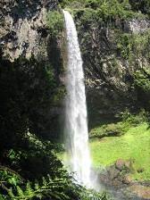
The rocks around the pool are mainly soft sandstones that have been worn down by the river to form a large amphitheatre. If you look up at the cliff face you can see the band of hard basalt rock that has resisted the erosive power of the river and now forms the lip of the spectacular 55-metre falls.  It seems like human construction, but the regular columns are a freak of nature known as columnar basalt.  basalt. This rock formation was created some two and a half million years ago when molten lava from a volcanic eruption flowed down a river course, pooling in a valley. As the lava slowed, the top and bottom started to cool and shrink. Cracks and joints appeared, running
directly down from the surface of the flow. Because the hotter and semi-liquid part of the lava was still moving the joints developed a distinctive curve.

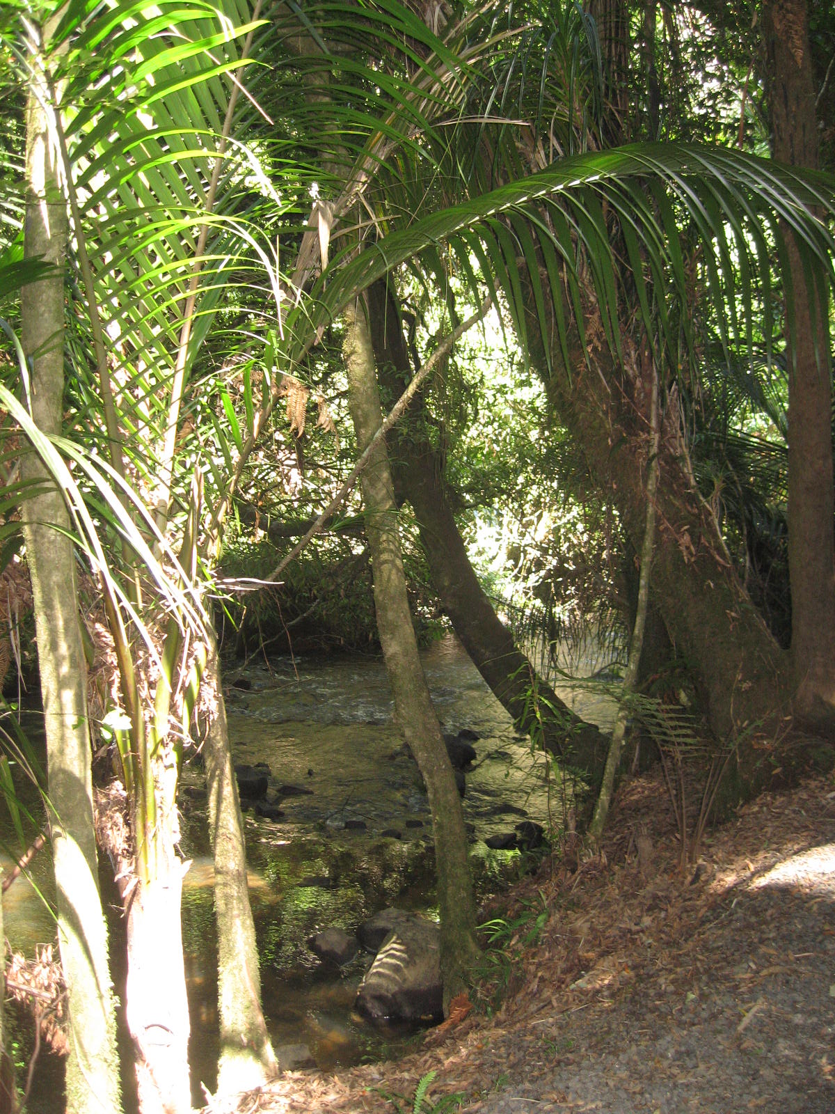
Around the pool there are many nikau palms that thrive in the micro climate.

Polls

In June 2021 a 'painted roundlet' was opened by the Mayor at the intersection of Bow and Wainui. What needs to be done to this intersection?

View Results

  • Polls Archive

Raglan Radio Programmes

CLICK HERE for more on RAGLAN RADIO
≡ Menu
  • Home
    • About Raglan Website
  • Site Map
  • Contact Us & Advertising
    • Classifieds
  • Raglan Weather
    • Raglan Weather Maps
  • About Raglan Weather
  • Raglan Webcam
  • Raglan Tides
fb
twitter
rss feed
Instagram
Google Plus

Latest Raglan News

  • Council brings Freddie back
  • Jun 1: Ramblers climbing Karioi from Ruapuke
  • Council adopts rate to cover Raglan food waste collection costs
  • Covid test pick up site moves to Raglan Food Bank
  • 200 litre effluent tanks an issue with cows producing 52 litres a day

Earlier Raglan News

Recent Comments

  • Steve Hutcheson on Waoku Lodge & Moana Day SpaHi there, I'm trying to organize a day spa for the mrs and a couple of friends for her birthday..
  • John Lawson on May 4: Raglan Community Board meeting1.30pm Community Board meeting no longer at Supper Room, but on-line - https://us02web.zoom.us/j/5111086998 Meeting ID: ..
  • Aeireira on Kokiri Centre Riria Kereopa MemorialTena tātou, Just wondering who I contact in regards to booking of the facilities please. We are looking at holding..
  • Edward Prince on At 85% fully vaccinated Whāingaroa is behind lowest DHB on 86%How embarrassing Raglan and surrounds, bottom of the list. Must try harder.
  • Edward Prince on Whāingaroa Covid vax behind lowest DHByep i think we are getting down to the hard core anti vaxxers now. Not surprising considering all the hippie..
Copyright Raglan 23: 2021