
As of 2nd February there is no SEVERE WEATHER WARNING for the Waikato in place.
Raglanders should take care of high water levels in the harbour caused by the King Tides and recent rainfall.
{SWW Event 2018/0201.1050}
NOT TO BE BROADCAST AFTER 09:00pm Thursday 01-Feb-2018
SEVERE WEATHER WARNING
Issued by MetService at 10:50 am Thursday 01-Feb-2018
Major storm is forecast to hit the South Island with significant
heavy rain and strong winds for much of the South Island, also for
the parts of the North Island.
Update to add Taihape and Whanganui Hill Country to the Strong Wind
Warning.
A major storm (former Tropical Cyclone Fehi) is moving southeast
across the South Island during today (Thursday). It should then move
away to the southeast of New Zealand on Friday. This storm brings
significant heavy rain and possible damaging winds to much of the
South Island and parts of the North Island until Friday morning.
The heaviest rain is expected in the South Island (apart from
Canterbury Plains and Kaikoura Coast), especially in Westland and
Fiordland where a further 200 to 350mm of rain could accumulate in
addition to what has already fallen until early Friday. Heavy rain is
also expected for Tararua Range, MT Taranaki, Bay of Plenty, Rotorua,
Gisborne ranges and now Waikato, Waitomo, Taumarunui, Taupo and
Taihape . A Heavy Rain Warning is in force for these areas.
In addition, gale force winds are expected for southern and central
New Zealand,initially from the north, but turning northwest then
southwest during today (Thursday). The strongest winds are likely to
be in Westland, Buller, Canterbury High Country, Nelson, Marlborough ,
Wellington and southern Taranaki, and a Strong Wind Warning is in
force for these areas.
People are strongly urged to keep up to date with the latest
forecasts and warnings in case other areas will be added to the
Warning.
==================
HEAVY RAIN WARNING
==================
Heavy rain may cause streams and rivers to rise rapidly. Surface
flooding and slips are also possible and driving conditions may be
hazardous.
Area: Waikato, Waitomo, Taumarunui, Taupo, and Taihape
Valid: 14 hours from 10:00 am Thursday to 12:00 am Friday
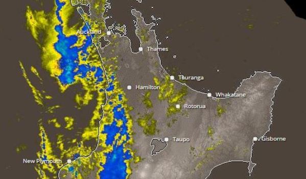
Forecast: Rain with heavy falls is forecast to set in this (Thursday)
morning,easing around midnight tonight. Expect 80 to 130mm of rain to
accumulate, mainly about the ranges. Peak intensities of 20 to 40mm
per hour in possible thundery downpours.
Change note: The Watch for heavy rain has now been upgraded to a
Warning.