
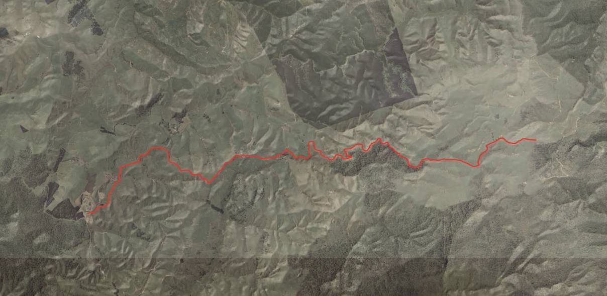
The Pipiwharauroa Walking and Biking Trail is open for public use. The track goes over privately-owned farmland and paper roads on the Wharauroa Plateau. Crossing steep to rolling terrain, the 18 kilometre return trip takes approximately four hours to walk or two hours to cycle. During August, September and October the sections of the trail on farm land are closed for lambing.
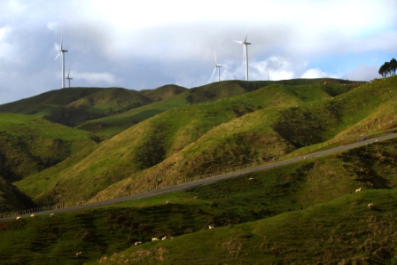
At 430 metres above sea level, the trail winds over the Te Uku Wind Farm site which affords outstanding 360 degree views across the greater Waikato, to include Raglan, Kawhia and Aotea harbours, and on a clear day, Mt Taranaki.
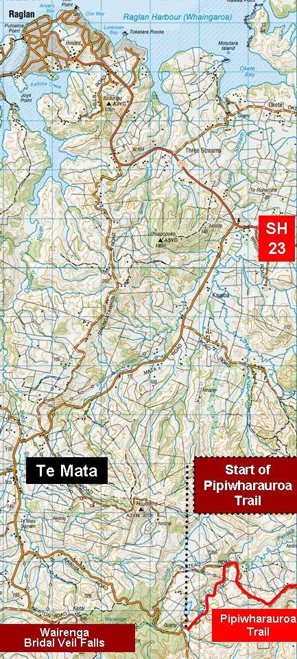 Access to the track is at the western end from the old Kawhia Road. Head back towards Hamilton from Raglan along SH 23. Or driving from Hamilton turn left a few kilometres past Te Uku. From SH 23 turn off onto the Te Mata Road and the follow the signs towards the Wairenga Bridal Veil Falls. Drive through Te Mata village and continue onto the Falls. Continue past the Falls to a quarry and just past that is the signposted access to the Pipiwharauroa Trail. Weather conditions are changeable and it is important hikers and cyclists prepare for potential changing weather conditions typical to this area. Cyclists and walkers are required to keep to the track which covers private farmland.
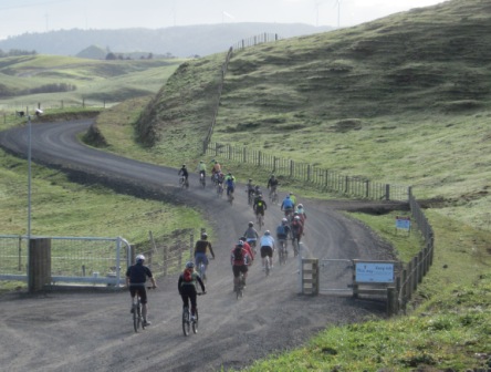
The track was opened at 9am on the 27th August. After an early morning opening ceremony, a group from the Raglan Mountain-biking Club were the first to experience the track over privately-owned farmland on the Wharauroa Plateau. The name, Pipwharauroa Trail was decided after the public were given the opportunity to submit a name for the track to the Waikato Times. From the 54 entries received, the name was chosen by a panel represented by the land owners, Meridian Energy- owner and operator of the Te Uku Wind Farm, Ngaati Maahanga and Waikato District Council.
The winning name was submitted by Brenda and Trevor George of Ohaupo, whose successful entry will be shown on a plaque to be installed at the site. The couple submitted the following wording to support their entry: Maaori used to travel this route to harvest pipiwharauroa, the shining cuckoo. They followed this trail in search of the bountiful supply of fresh food. The return of these birds from their winter migration indicated it was time to plant spring crops.
At the summit, a historic site treasured by local iwi, Ngaati Maahanga is known as Te Tiho o Tonganui. The site pays homage to three ancestors, Mahanga the eponymous ancestor and namesake of the tribe, Tonganui the warrior and Hone Waitere, the last Maaori owner of the Wharauroa block.
The formation of the Pipiwharauroa Trail over existing paper roads was made possible with the co-operation and goodwill of the landowners. The track winds its way over private farmland owned by the Vanhoutte and Jowsey families who have a long association with the area. The Vanhoutte family’s ties to the area date to 1897, when Maurice Vanhoutte’s grandfather, Belgian immigrant Benoit Vanhoutte, settled on the windswept plateau. The project is a joint initiative by Waikato District Council, Meridian Energy and landowners. The trail opened to the public on Saturday 27 August 2011.
A little disappointed at the lack of detail for this trail. It appears exciting and fine to give historical info but why does it take 2 hours to cycle 18 Kms. Is it very hilly, %age flat to hilly. What is the surface made of. Does it meander between the hills, ect. Would love more details. Hope to do this asp. Thanks
Yes I agree – lack of detail is disappointing. I’ll add information as Waikato District Council provides it.
Waikato District Council says, “There will be a brochure and posters supplied closer to the time of opening. The access is from Kawhia Road, the trail starts at the car park and returns there. It is 18km long. There has been a lot of publicity in the Waikato Times (an editorial campaign over four weeks), stories in our Link magazine which is distributed throughout our district, and the media release sent out last week. As the trail has been created over paper roads that have had to be legalised and the access is over private farmland we have listened to the landowners and not announced the opening until three weeks from the launch. The landowners have had a number of trespassers up there and so we couldn’t promote the track until it is opened. Brochures and posters will be supplied closer to the opening and distributed to I-Sites, DOC and Raglan tourism ventures. We will be releasing more information this week. “
Thanks to the land-owners, WDC & Meridian for the opportunity to access this area. I am looking forward to having a ride on the track. We need more places to MTB (mountain bike) in Raglan area & if all goes well with landowners / public relations, this area could potentially become a MTB destination for locals & tourists – there are a lot of positives for the whole community if this is succesfull.
Coulcn’t agree more. With hydro lakes the community often gets a superb lake for recreation- Karapiro comes to mind. Now we have wind farm that is yielding a great community resource.
the track is mainly gravel (well graded as they had to get the turbines up there) it does divert over some farm land that shouldnt be too bad unless its been raining, maybe 5k’s mainly flat then steep like the photo above then flattens out again for the last few k’s, id say the 2 hours would be for family and kids kind of thing allowing for breaks etc, wouldnt take long to come back down!!, ive worked up there too so not one of the trespassers
Hi Rodger
I would like to let you know that Raglan Scenic Tours is able to hire guests bikes and provide transport to and from the Pipiwharauroa Biking Trail
Thanks
Thanks Keith. Good to know. Seems to be a strong interest in the Trail.
Just walked the trail today and it is fantastic! Took my toddler in her pram and both really enjoyed it. Can see it being hugely popular and am looking forward to walking (or biking) it again. A big thank you to the farm owners who have made it possible and all organisers involved in making it happen!
A group of us walked this trail yesterday. Perhaps a sign marking the 5k point would be helpful. Also, how far up is the plaque about John Key opening the trail?
John Key opened the wind farm- probably a plaque on the top of the hill, he didn’t open the trail. The Trail was opened by kaumatua, WDC officals and a rep. of the land owners – the plaque is by the car park.
Are dogs allowed on the track?
Waikato Distrcit Council says, “NO DOGS OR MOTORBIKES ARE PERMITTED ON THE TRAIL AT ANY TIME.”
On sunday march the 11th, Matamata Tramping and Walking Club went for a walk up here. we all enjoyed the walk very much and think the turbines are fairly quiet. I would like to see more markings at the sumit as this wasn’t clearly marked and maybe a composting toilet at the start and at the sumit. A good and well maintained track for all.
I’ve let the Facilities Manager at WDC know about your comments.
Thanks,
Rodger
I rode the trail today and enjoyed it very much.
From a mountain biking point of view it offered a variety of surfaces and riding conditions.
The climb to the top was moderately taxing and would require a reasonable level of fitness.( although not superman stuff by any means).
The decent back down was great fun while not overly challenging.
There are e few corners with drops on the outside to be careful of though.
My only negative comment would be the poor signage near the end and I don’t think I found the actual summit which was a little dissapointing.
It’s great to see tracks like this being built and a big “well done” to those involved,Thank you.
Pipiwharauroa Trail temporarily closed for August and September 2012
The 18 kilometre long Pipiwharauroa Trail on the Wharauroa Plateau will be temporarily closed to the public during lambing season.
To support stock welfare, the walking and cycling trail which winds over the Te Uku wind farm site and privately-owned farmland will be closed during August and September.
Waikato District Council general manager of Water & Facilities, Richard Bax, said the trail will be temporarily closed to the public to keep the area as quiet as possible during the lambing season.
I went to ride the track today and was really enjoying it until about 3km into the ride when there was a sign “Track closed for lambing – keep out” on the cycle track gate near the farm house. I thought track was meant to be open again from the 1st of October? Maybe it’s a late lambing season and the land owners don’t whish cyclists to continue past this point yet? Anyone know?
I’ve asked Waikato District Council to confirm that the track is open now.
Rodger, sorry for the delay in responding. The track had been re- opened but a sign had been missed.
We biked this trail (track) today I see from the comments that in 2011 a lady walked this trail with her baby in a pram, that would be impossible now the grass tracks through the farmland are very rutted with very rough terrain. This is not a track for the novice rider , although the gravel road easy if you don’t mind 3km of corrigations.